Please object to 500 homes off Thompsons Road, Keresley OUT/2019/0484
Deadline Wed 12 noon 26th May (the planning committee will decide on Thursday 27 May)
Send your comments to
Give this reference: 500 homes off of Thompsons Road Keresley OUT/2019/0484
Points you may wish to include:
- The homes are not needed.
- There is enough brownfield left for 10 years at current rates of building. The council should now put on hold all planning decisions relating to former green belt land.
- The evidence for removing this land from green belt has collapsed. The Office of Statistics Regulation [OSR], on 10 May 2021, found that the population forecasts, were “inconsistent with local data and potentially too high”. In plain language, it means that there has been no sign of extra school admissions, additional A&E attendance, extra gas and electric usage, more pensions or voters, more births, more deaths, more waste in domestic bins, than there has been in the past, when growth was just average. The detail is well known to the council.
- In her report, Rebecca Phillips, the local plan inspector cited “significant growth” [para 106] as the “exceptional circumstance”, to justify removing land from green belt. Following the OSR report, there is no evidence of “significant growth” and no reason to remove the land from green belt.
- The correct course of action is return this land to green belt, as Leeds City Council is currently doing, at the direction of the High Court, in response to reduced 2016 population projections.
- The council should place all planning decisions on former green belt on hold, until ONS revises the population projections and estimates, as OSR have instructed ONS. ONS is required to present a plan of action by July 2021.
- In the alternative, the council should put all decisions about former green belt, on hold, until March 2022, when the census will give reliable figures for Coventry.
- Building homes on the outskirts of Coventry is unsustainable.
- Homes on the fringes have 2 to 4 times the carbon footprint of city centre dwellings. Building here, with its greater carbon footprint, , is contrary to the Council declaration of a climate emergency in 2020.
- The transport assessments are unsound. There is no evidence that 10% of the residents will switch to bikes, walking and buses. Council officers can cite only one case in England where a modal shift like this has occurred, at Northstowe in Cambridgeshire and that is not comparable to Keresley – it’s a new town, with dedicated cycleways, and a guided busway. No rapid transit is remotely possible on Bennetts Road or the Tamworth Road, and the area is far too hilly to expect commuters to cycle to work or schools.
- The standard used to assess the transport effects of development, the IEMA 1993 guidance, is invalid – it does not apply, in its own words, to matters of “highway capacity or operation.” It is far too lenient; effects less than 30% are not considered significant. Official transport guidance in Northern Ireland and Scotland considers even a 1% increase can be significant on busy roads.
- Much of the development will be more than 400 m from the nearest bus stop, contrary to the requirements of the local plan. Some homes will be 800 m from a bus stop.
- Coventry Council has obstructed residents obtaining relevant traffic modelling at Winding House Lane, Ricoh Arena, and J3 M6 – We are unable to effectively participate in assessing the traffic effects, contrary to the Aarhus Convention – currently the roads are already “severely” congested in the mornings, especially at J3 according to Highways England and a new traffic profile will potentially emerge across the NW quarter of the city once the Keresley Link is completed.
- These homes will wreak grievous harm onto the Ancient Arden landscape.
- Coventry Council pronounced, in their own 1995 landscape guidance, [This area is] “especially significant as it is now the only remaining relatively unspoilt area of ancient countryside remaining in Warwickshire”
- The development will ruin the view from the Ancient Monument – a Roman hill fort and stone age encampment – at the top of Corley Rocks. – see picture below.
- This development will damage the adjacent ancient woodlands, Bunson’s Wood.
- Woodland Trust guidance recommends a 50m buffer, and in the case of major developments, like this one, 100m. The Natural England standing guidance also recommends a broader buffer for larger developments. Their 15 m recommendation applies only to root protection and similarly requires greater protection for larger developments. Need for greater protection was not adequately considered. .
- Biodiversity will decline.
- Prowling cats, and dogs will exterminate ground nesting birds. Pet excreta will over fertilise the soil, giving rise to nettles buttercups, docks and other coarse species, at the expense of fragile woodland flora – like wood anemones, wood sorrel, yellow archangel, opposite leaved saxifrage, dogs mercury, hemp agrimony etc.
- Pets and the wind will bring seeds of coarse invasive species into the woods from gardens. (dock, mares tail, burdock, dandelion, buttercups, )
- Badgers, a protected species, will leave the area, reducing significant biodiversity.
- 13 Specialist farmland birds in the area, of particular interest to Natural England, have severely declined since 1970, and will lose habitat. Skylarks, lapwings, tree sparrows and yellow hammer will not live in a suburb.
- Fly-tipping, and littering inevitably will increase, particularly in the ancient woodland.
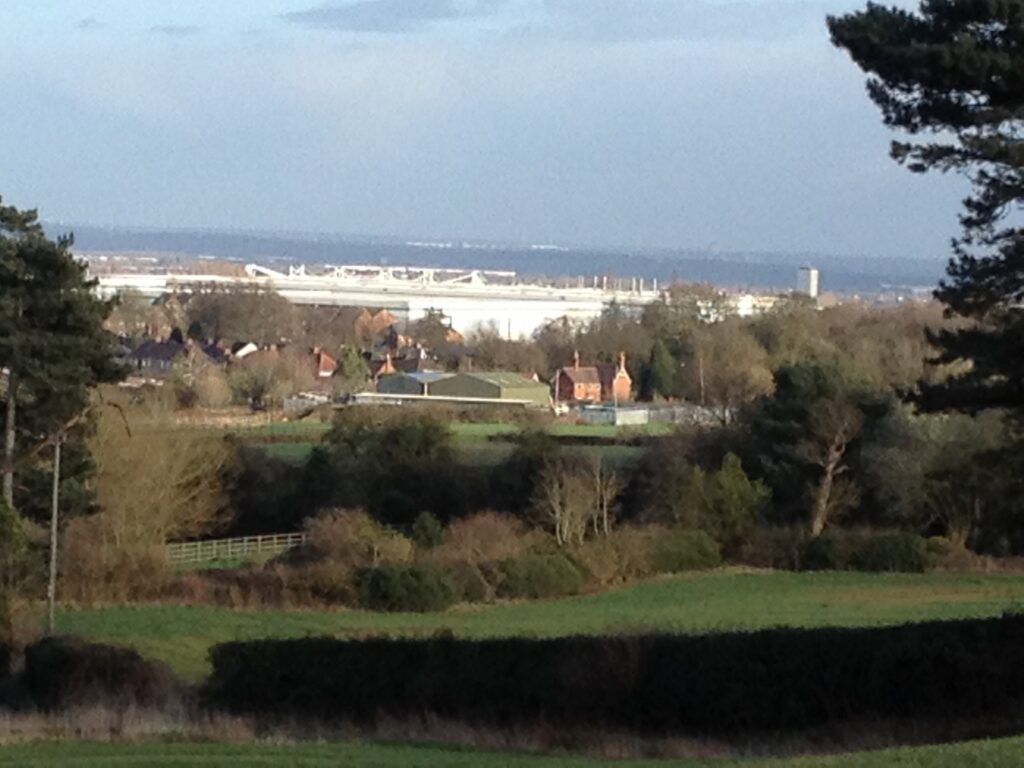
A picture taken from the Corley Hill Fort, has clear visibility of the land behind Thompsons Road.